Welcome to Saarbrücken!
It is the capital city of the Saarland, and host to a population of about 177,000 people. Some of these pictures I posted are from the different seasons and some of them I stole from people who are not me. I'll post more on the Saarland itself a little later.
 |
| The Saarland is the little blue spot in the left corner. Klein aber fein! |
A little historical background
Saarbrücken literally means 'Saar bridges'. Thanks to Wikipedia and the city website, I discovered the word, saar, comes from the Celtic word sara, meaning streaming water, and from the name the Romans gave the river the runs along the city, saravus.
 |
| Schloss Saarbrücken |
Now the bridges part, or Brücken, many people assume came about because there are many bridges that cross the river from one part of the city to the other. Very logical. However, there are three alternative theories to this:
1) Historical Saarbrücken was called Sarabrucca. Brucca is believed to be derived from the Celtic word brigga, meaning rock, or hill. Brigga later became Brocken in High German. The castle that is in Saarbrücken is built on a hill called Saarbrocken next to the Saar river.
2) Other people think that the historical name Saarbrucca came from the Old High German word Brucca which means bridge, or apparently, more specifically something called a Corduroy road* which is used in fords. (I had to look all this up.) There is a ford next to the castle by the river which was used to cross the river.
*A Corduroy road is also called a log road which is made by placing sand over logs perpendicular to the road. These kind of roads were used a lot during the Civil War and Sherman's march through the Carolinas.
3) The last theory, which has been rejected now, believes that brucca comes from the Germanic word bruco, meaning swap or marsh.There's an area nearby that was swampy back in the day, but this theory has been rejected because the area was originally settled by the Celts, and not the Germanic people.
 |
| Mithras shrine in Saarbrücken |
There's a Mithras shrine that was built during the 3rd C AD that still exists. I don't really have the energy to go into what Mithraism is, but basically it was a mystery religion practiced by the Romans from 1 AD- 4 AD and believed to have been adopted from Persia.
Let's take a closer look around.


First, let's start at the Schloss, or castle. Nowadays, it's not really a castle, but has been renovated and is used more for offices and so on. The first mention of Saarbrücken was in 999 under the name Castellum Saarbrucca.


In the 17th Century the castle was rebuilt in the Renaissance style, but then in the 18th Century it was renovated by the famous architect Friedrich Joachim Stengel into the Baroque style (left and right).
Since then, it's been destroyed in several wars and rebuilt. The most recent rebuilding was in 1989. And below, you can see what it looks like today.

 |
| Casement under the castle |
View of the river from the castle during the Saar Spektakel. The Saar Spektakel is a festival that takes place at the beginning of August and is celebrated with music, stands, and dragon boat races.

People enjoying a drink outside on the square in front of the castle.
Next, we will look at the Staatstheater (state theater) at Tbilisser Platz.
 |
| Named for Tbilisi, Georgia which is a twin city of Saarbrücken. |
The Staatstheater was first opened in 1938 with a performance of "The Flying Dutchman." It's said that the theater was actually built by Hitler as a gift to the Saarland for its contributions to the war effort, but no one really likes to talk about that now. Many times during festivals, the square in front of it is covered with a stage, and in the winter, with an ice skating rink.
 |
| Staatstheater Saarbrücken |
 |
| Staatstheater in the snowy background |
Next we'll move on the the Alte Brücke, or old bridge, next to the Staatstheater that goes across the Saar river and the highway into the area known as Alt Saarbrücken (old Saarbrücken) and the Schloss.

 The old bridge was originally built by Charles V in 1546 and had 14 arches.
 Now only 8 arches remain. It was destroyed during WWII, like everything else, and then rebuilt.
Below you will see the bridge from the top, one decorated and one plain. The church you see in the background is the Schlosskirche, or Castle Church. You basically had to sign a contract in order to take photos inside, so this is all you're going to see. The steeple was built in the 15th Century and in 1743 Stengel, who also redesigned the castle, gave it a Baroque touch. Like much of the city, it was destroyed during WWII, but rebuilt in the 50s.


Probably the most famous church is Saarbrücken is the Ludwigskirche (Ludwig's Church.) According to the Saarbrücken website, it is considered one of the "most stylistically and aesthetically perfect Protestant churches in Germany". Take that Frauenkirche in Dresden! It is another example of architecture designed by Stengel and was completed in 1775. Though it was totally destroyed during WWII, it was authentically restored.
 |
| Ludwigskirche. The heart of Saarbrücken. |
 |
| Inside of the Ludwigskirche |

Area around the Ludwigskirche.
 |
| Backside of the Ludwigskirche |
Below you will see winter scenes around the Ludwigskirche. On the left you'll see the statues in front of the Ludwig's Square and on the right you will see the church in the background.


The next place we'll take a look at is St Johanner Markt. It's a big open market area with shops and restaurants and little boutiques. I have some pictures from the Christmas market that comes in December.


One thing they do every Christmas is Santa will fly over the Christmas market. There actually is a man up there waving and a chick in a cloud hanging below also waving. Santa flies over and through a loud speaker you hear the story of Christmas. At least that's what I think it is. Usually, I'm tipsy on Glühwein at this point and it's a little hard to understand. It's pretty fun though. I normally turn into a 5 year old when Santa flies over.
 |
| This is not my photo, but you can see the market better. |

The yellowish building on the corner is a restaurant called Tante Maya. Allegedly, back in the day it used to be a brothel. When people said they were going to St Johanner Markt to "pick up a few things" they probably meant STDs....if you get my drift. Aunt Maya indeed. But now it's a very respectable area.
 |
| It's flooded before. You can see the fountain I'm about to tell you about in the background. |

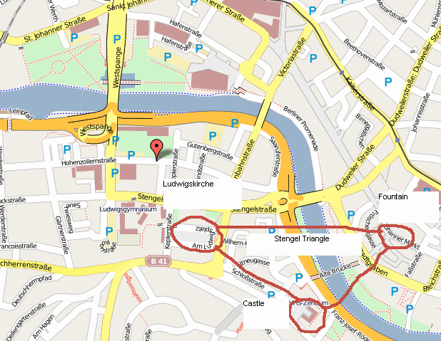
Oh look. I drew you a map of the Stengel triangle. I enjoy visuals.

So that is what I will leave you with for now. Naturally, there is much more to see in Saarbrücken and there's much more to the history, especially during WWII and how it became a mining town, but that will be for another time.
 |
| View of the Castle Church steeple from the river |
No comments:
Post a Comment